I have had a go at mapping Scotland’s bioregions.
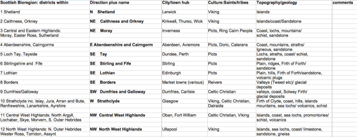
Certain regions have longstanding historical and cultural associations eg. The Lothians, Moray and Fife. Others are archipelagos: the Orkneys, Shetlands and Hebrides. I see these island groupings as a key pattern, for are not the “Wise” Isles (Wales, Ireland, Scotland, and England) one big archipelago sitting off the coast of continental Europe?
Some colleagues working on English bioregions are basing them on water catchment systems. This pattern works for the Tay and Tweed catchments, but in Scotland there is another “water” pattern of glaciated marine Firths: Solway, Clyde and Forth. The latter two, of course, include the nation’s biggest cities: Glasgow and Edinburgh.
I have spoken to folk in different parts of Scotland about bioregions and they tend – quite naturally – to define them in much smaller terms. I’ll give three examples: the Kintyre peninsula (where I live), the Cowal grouping of five peninsulas and the Isle of Arran, all of them in the Clyde.
However, when I think about a bioregion I think of an area of similar climate united by a common topography. This leads to a unique “agroeconomic region” (Meadows, 1982). I’d say that the three examples mentioned above all fall under the Strathclyde bioregion.
This is very much a work in progress and I would like feedback especially from those who do not live in my home area of SW Scotland.
People ask me: “What’s the purpose?” Fair enough. I am envisioning a time when each bioregion will have a centre to which people go and learn about their regional resources and how to interact with them sustainably.
One last point about my map. It shows the inadequacy of political boundaries. Neither of the two bioregions in the south of Scotland (Solway Firth and the Tweed catchment), respect the English/Scottish border. The north coast of the Solway is in Scotland, the south in England; and whilst most of the Tweed catchment is in Scotland a portion of it is in Northumberland.
